
Make a donation
Gear up for your next adventure:
As an Amazon Associate, this site earns from qualifying purchases at no extra cost to you.
Lake Champlain topographic map
Click on the map to display elevation.
Make a donation
Gear up for your next adventure:
As an Amazon Associate, this site earns from qualifying purchases at no extra cost to you.
About this map
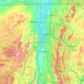
Name: Lake Champlain topographic map, elevation, terrain.
Location: Lake Champlain, Chittenden County, Vermont, United States (43.58320 -73.46064 45.08509 -73.07591)
Average elevation: 1,165 ft
Minimum elevation: 82 ft
Maximum elevation: 5,062 ft
Chittenden County trails, hiking, mountain biking, running and outdoor activities
Make a donation
Gear up for your next adventure:
As an Amazon Associate, this site earns from qualifying purchases at no extra cost to you.
Other topographic maps
Click on a map to view its topography, its elevation and its terrain.
Starr Farm Beach
United States > Vermont > Chittenden County > South Burlington
Average elevation: 112 ft
Make a donation
Gear up for your next adventure:
As an Amazon Associate, this site earns from qualifying purchases at no extra cost to you.
Huntington Center
United States > Vermont > Chittenden County > Huntington
Average elevation: 1,056 ft
Make a donation
Gear up for your next adventure:
As an Amazon Associate, this site earns from qualifying purchases at no extra cost to you.
South Burlington
United States > Vermont > Chittenden County > South Burlington > South Burlington
Average elevation: 282 ft
Make a donation
Gear up for your next adventure:
As an Amazon Associate, this site earns from qualifying purchases at no extra cost to you.
Fays Corner
United States > Vermont > Chittenden County > Richmond > Fays Corner
Average elevation: 758 ft