
Make a donation
Gear up for your next adventure:
As an Amazon Associate, this site earns from qualifying purchases at no extra cost to you.
Santa Cruz Island topographic map
Click on the map to display elevation.
Gear up for your next adventure:
As an Amazon Associate, this site earns from qualifying purchases at no extra cost to you.
About this map
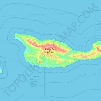
Name: Santa Cruz Island topographic map, elevation, terrain.
Average elevation: 121 ft
Minimum elevation: 0 ft
Maximum elevation: 2,356 ft
Santa Barbara County trails, hiking, mountain biking, running and outdoor activities
Make a donation
Gear up for your next adventure:
As an Amazon Associate, this site earns from qualifying purchases at no extra cost to you.
Other topographic maps
Click on a map to view its topography, its elevation and its terrain.
Vandenberg Village
United States > California > Santa Barbara County > Lompoc
Average elevation: 433 ft
Make a donation
Gear up for your next adventure:
As an Amazon Associate, this site earns from qualifying purchases at no extra cost to you.
North Santa Maria
United States > California > Santa Barbara County > Santa Maria
Average elevation: 213 ft
Jalama Beach County Park
United States > California > Santa Barbara County > Jalama
Average elevation: 131 ft
Shoreline Park
United States > California > Santa Barbara County > Santa Barbara
Average elevation: 69 ft
Make a donation
Gear up for your next adventure:
As an Amazon Associate, this site earns from qualifying purchases at no extra cost to you.
Make a donation
Gear up for your next adventure:
As an Amazon Associate, this site earns from qualifying purchases at no extra cost to you.
Make a donation
Gear up for your next adventure:
As an Amazon Associate, this site earns from qualifying purchases at no extra cost to you.
Make a donation
Gear up for your next adventure:
As an Amazon Associate, this site earns from qualifying purchases at no extra cost to you.
Las Positas Meadows
United States > California > Santa Barbara County > Santa Barbara
Average elevation: 217 ft