
Salthill topographic map
Interactive map
Click on the map to display elevation.
About this map
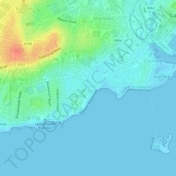
Name: Salthill topographic map, elevation, terrain.
Location: Salthill, Galway, County Galway, Connacht, Ireland (53.25712 -9.08033 53.26941 -9.06426)
Average elevation: 30 ft
Minimum elevation: -3 ft
Maximum elevation: 148 ft
Other topographic maps
Click on a map to view its topography, its elevation and its terrain.
Merlin Park
Ireland > County Galway > Galway
Merlin Park, Ballybane, Ballybaan, Galway, County Galway, Connacht, Ireland
Average elevation: 82 ft
Galway City
Ireland > County Galway > Galway
Galway City, Galway, County Galway, Connacht, Ireland
Average elevation: 49 ft