
Make a donation
Gear up for your next adventure:
As an Amazon Associate, this site earns from qualifying purchases at no extra cost to you.
Antony topographic map
Click on the map to display elevation.
Make a donation
Gear up for your next adventure:
As an Amazon Associate, this site earns from qualifying purchases at no extra cost to you.
Antony
Antony is a city in the southern suburbs of Paris in the Hurepoix and is the chief town of the arrondissement of Hauts-de-Seine - 12.2 km south of Notre-Dame Cathedral. Its altitude is 48m above sea level at the lowest point at rue Gabriel Chamon in the Bièvre Valley and 100m at the highest point in the Avenue d'Estienne d'Orves on the border with Châtenay-Malabry. Antony is at the intersection of three departments.
Make a donation
Gear up for your next adventure:
As an Amazon Associate, this site earns from qualifying purchases at no extra cost to you.
About this map
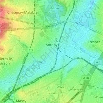
Name: Antony topographic map, elevation, terrain.
Average elevation: 249 ft
Minimum elevation: 151 ft
Maximum elevation: 492 ft
Make a donation
Gear up for your next adventure:
As an Amazon Associate, this site earns from qualifying purchases at no extra cost to you.
Other topographic maps
Click on a map to view its topography, its elevation and its terrain.
Jardin de la Mairie
France > Ile-de-France > Hauts-de-Seine > Boulogne-Billancourt
Average elevation: 171 ft
Make a donation
Gear up for your next adventure:
As an Amazon Associate, this site earns from qualifying purchases at no extra cost to you.
Hameau de Bois Preau
France > Ile-de-France > Hauts-de-Seine > Rueil-Malmaison
Average elevation: 295 ft