
Manaus topographic map
Interactive map
Click on the map to display elevation.
About this map
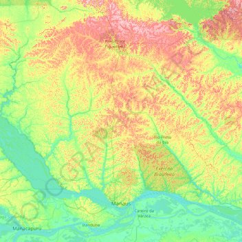
Name: Manaus topographic map, elevation, terrain.
Average elevation: 223 ft
Minimum elevation: 16 ft
Maximum elevation: 748 ft
Other topographic maps
Click on a map to view its topography, its elevation and its terrain.
Pico da Neblina
Brazil > Amazonas > Santa Isabel do Rio Negro
For 39 years, based on an uncontested measurement performed in 1965 by topographer José Ambrósio de Miranda Pombo, using a theodolite, the elevation of Pico da Neblina was thought to be 3,014 metres (9,888 ft), but a much more accurate measurement performed in 2004 with state-of-the-art GPS equipment by…
Average elevation: 7,146 ft
Amazon River
During what many archaeologists called the formative stage, Amazonian societies were deeply involved in the emergence of South America's highland agrarian systems. The trade with Andean civilizations in the terrains of the headwaters in the Andes formed an essential contribution to the social and religious…
Average elevation: 36 ft
Amazon River
Brazil > Amazonas > Itacoatiara
During what many archaeologists called the formative stage, Amazonian societies were deeply involved in the emergence of South America's highland agrarian systems. The trade with Andean civilizations in the terrains of the headwaters in the Andes formed an essential contribution to the social and religious…
Average elevation: 36 ft
Amazon River
Brazil > Amazonas > Careiro da Várzea
During what many archaeologists called the formative stage, Amazonian societies were deeply involved in the emergence of South America's highland agrarian systems. The trade with Andean civilizations in the terrains of the headwaters in the Andes formed an essential contribution to the social and religious…
Average elevation: 69 ft
Amazon River
During what many archaeologists called the formative stage, Amazonian societies were deeply involved in the emergence of South America's highland agrarian systems. The trade with Andean civilizations in the terrains of the headwaters in the Andes formed an essential contribution to the social and religious…
Average elevation: 36 ft
Ilha de Curupira
Brazil > Amazonas > Santa Isabel do Rio Negro > Santa Isabel do Rio Negro
Average elevation: 115 ft
Espirito Santo
Brazil > Amazonas > Santa Isabel do Rio Negro > Santa Isabel do Rio Negro
Average elevation: 128 ft
Presidente Figueiredo
Brazil > Amazonas > Presidente Figueiredo > Presidente Figueiredo
Average elevation: 364 ft