
Make a donation
Gear up for your next adventure:
As an Amazon Associate, this site earns from qualifying purchases at no extra cost to you.
Nayarit topographic map
Click on the map to display elevation.
Make a donation
Gear up for your next adventure:
As an Amazon Associate, this site earns from qualifying purchases at no extra cost to you.
About this map
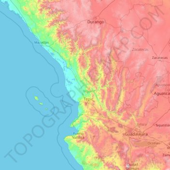
Name: Nayarit topographic map, elevation, terrain.
Location: Nayarit, Mexico (19.44000 -107.56000 24.56000 -102.44000)
Average elevation: 3,409 ft
Minimum elevation: -7 ft
Maximum elevation: 13,005 ft
Make a donation
Gear up for your next adventure:
As an Amazon Associate, this site earns from qualifying purchases at no extra cost to you.
Other topographic maps
Click on a map to view its topography, its elevation and its terrain.
Make a donation
Gear up for your next adventure:
As an Amazon Associate, this site earns from qualifying purchases at no extra cost to you.
Make a donation
Gear up for your next adventure:
As an Amazon Associate, this site earns from qualifying purchases at no extra cost to you.
San Pedro Lagunillas
Most of the municipality belongs to a volcanic zone. The main elevations are "Cerro Grande"(2,000 meters), "Cerro Tetillas" (1,760 meters), "Cerro La Palma" (1,740 meters), "Cerro Estiladero" (1,600 meters), "Cerro El Carretón" (1,580 meters), and the extinct volcano of "Tepetiltic" (1,500 meters).
Average elevation: 3,606 ft
Make a donation
Gear up for your next adventure:
As an Amazon Associate, this site earns from qualifying purchases at no extra cost to you.