
Leeds topographic map
Interactive map
Click on the map to display elevation.
About this map
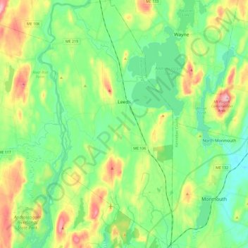
Name: Leeds topographic map, elevation, terrain.
Location: Leeds, Androscoggin County, Maine, 04263, United States (44.20618 -70.19883 44.37139 -70.07426)
Average elevation: 354 ft
Minimum elevation: 154 ft
Maximum elevation: 774 ft
Androscoggin County trails, hiking, mountain biking, running and outdoor activities
Other topographic maps
Click on a map to view its topography, its elevation and its terrain.
East Livermore
United States > Maine > Androscoggin County > Livermore Falls
Average elevation: 364 ft