
Groveland topographic map
Interactive map
Click on the map to display elevation.
Groveland
Groveland is a census-designated place (CDP) in Tuolumne County, California. Groveland sits at an elevation of 3,136 feet (956 m). The 2020 United States census reported Groveland's population was 540.
About this map
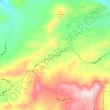
Name: Groveland topographic map, elevation, terrain.
Average elevation: 2,946 ft
Minimum elevation: 2,316 ft
Maximum elevation: 3,599 ft
Tuolumne County trails, hiking, mountain biking, running and outdoor activities
Other topographic maps
Click on a map to view its topography, its elevation and its terrain.
Sonora
United States > California > Tuolumne County
Sonora is located at 37°59′04″N 120°22′54″W / 37.984361°N 120.381767°W / 37.984361; -120.381767, around the intersection of California State Highways 49 and 108 The altitude is 1,825 feet (556 m). According to the United States Census Bureau, the city has a total area of 3.1 square miles…
Average elevation: 2,018 ft
Soulsbyville
United States > California > Tuolumne County > Willow Springs
Average elevation: 2,989 ft
Sonora
United States > California > Tuolumne County
Sonora is located at 37°59′04″N 120°22′54″W / 37.984361°N 120.381767°W / 37.984361; -120.381767, around the intersection of California State Highways 49 and 108 The altitude is 1,825 feet (556 m). According to the United States Census Bureau, the city has a total area of 3.1 square miles…
Average elevation: 2,018 ft
Columbia
United States > California > Tuolumne County
Columbia is located along State Route 49 just north of Sonora, at an altitude of 2,139 feet (652 m).
Average elevation: 2,205 ft