
Hinckley Township topographic map
Interactive map
Click on the map to display elevation.
About this map
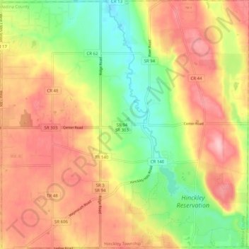
Name: Hinckley Township topographic map, elevation, terrain.
Location: Hinckley Township, Medina County, Ohio, 44233, United States (41.20151 -81.78509 41.27715 -81.68494)
Average elevation: 1,102 ft
Minimum elevation: 846 ft
Maximum elevation: 1,329 ft
Medina County trails, hiking, mountain biking, running and outdoor activities
Other topographic maps
Click on a map to view its topography, its elevation and its terrain.