
Make a donation
Gear up for your next adventure:
As an Amazon Associate, this site earns from qualifying purchases at no extra cost to you.
Stillwater Township topographic map
Click on the map to display elevation.
Make a donation
Gear up for your next adventure:
As an Amazon Associate, this site earns from qualifying purchases at no extra cost to you.
Stillwater Township
Flanked to the west by Kittatinny Mountain, the Stillwater Township is located within the Ridge and Valley Physiographic Province, and the entire township is within the Kittatinny Valley a region of rolling hills and flat valley floors that is a section of the larger Great Appalachian Valley running 700 miles (1,100 km) from eastern Canada to northern Alabama. Elevations in this valley range from 400 to 1,000 feet (120–300 m). According to Snell, "The surface of the country is generally uneven and hilly, and on the west exceedingly rugged and mountainous. Ponds and watercourses abound. Of the latter, the most important is the Paulinskill, a millstream of considerable consequence." All of Stillwater Township is located in the Paulins Kill watershed which flows southwest through Sussex and Warren counties before joining the Delaware River near Columbia, New Jersey. The valley floor is part of the Ordovician Martinsburg Formation (shale and slate) which make up most of the valley—and the Jacksonburg Formation (mostly limestone).
Make a donation
Gear up for your next adventure:
As an Amazon Associate, this site earns from qualifying purchases at no extra cost to you.
About this map
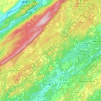
Name: Stillwater Township topographic map, elevation, terrain.
Average elevation: 801 ft
Minimum elevation: 308 ft
Maximum elevation: 1,578 ft
Sussex County trails, hiking, mountain biking, running and outdoor activities
Make a donation
Gear up for your next adventure:
As an Amazon Associate, this site earns from qualifying purchases at no extra cost to you.
Other topographic maps
Click on a map to view its topography, its elevation and its terrain.
Make a donation
Gear up for your next adventure:
As an Amazon Associate, this site earns from qualifying purchases at no extra cost to you.
Make a donation
Gear up for your next adventure:
As an Amazon Associate, this site earns from qualifying purchases at no extra cost to you.
Kittatinny Mountain
United States > New Jersey > Sussex County
Kittatinny Mountain (Lenape: Kitahtëne) is a long ridge traversing primarily across Sussex County in northwestern New Jersey, running in a northeast-southwest axis, a continuation across the Delaware Water Gap of Pennsylvania's Blue Mountain (also known as Kittatinny Ridge). It is the first major ridge in the…
Average elevation: 873 ft
High Point
United States > New Jersey > Sussex County > Montague Township
High Point is a mountain peak within High Point State Park on the border of Wantage Township and Montague Township, Sussex County, New Jersey. Located in the portion of the state known as the Skylands, it is the highest elevation in the state, with a peak elevation of 1,803 feet (550 m). The closest city is…
Average elevation: 1,362 ft
Make a donation
Gear up for your next adventure:
As an Amazon Associate, this site earns from qualifying purchases at no extra cost to you.
Make a donation
Gear up for your next adventure:
As an Amazon Associate, this site earns from qualifying purchases at no extra cost to you.
Halsey
United States > New Jersey > Sussex County > Hampton Township > Hampton Township
Average elevation: 610 ft
Hampton Township
United States > New Jersey > Sussex County > Hampton Township
Average elevation: 663 ft
Fredon Township
United States > New Jersey > Sussex County > Fredon Township
Average elevation: 728 ft
Make a donation
Gear up for your next adventure:
As an Amazon Associate, this site earns from qualifying purchases at no extra cost to you.
High Point
United States > New Jersey > Sussex County > Montague Township
High Point is a mountain peak within High Point State Park on the border of Wantage Township and Montague Township, Sussex County, New Jersey, United States. Located in the portion of the state known as the Skylands, it is the highest elevation in the state, with a peak elevation of 1,803 feet (550 m). The…
Average elevation: 1,362 ft
Montague
United States > New Jersey > Sussex County > Montague Township > Montague
Average elevation: 584 ft
Make a donation
Gear up for your next adventure:
As an Amazon Associate, this site earns from qualifying purchases at no extra cost to you.
Wallpack Center
United States > New Jersey > Sussex County > Wallpack Township
Average elevation: 587 ft