
Winter Harbor topographic map
Interactive map
Click on the map to display elevation.
About this map
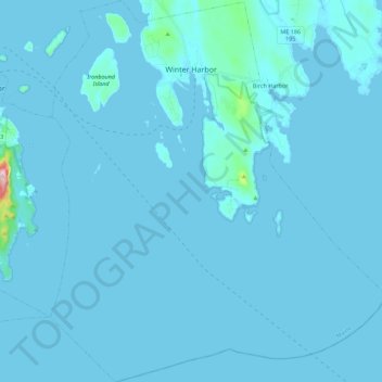
Name: Winter Harbor topographic map, elevation, terrain.
Location: Winter Harbor, Hancock County, Maine, 04693, United States (44.26438 -68.16614 44.42425 -67.96932)
Average elevation: 23 ft
Minimum elevation: -10 ft
Maximum elevation: 1,024 ft
Hancock County trails, hiking, mountain biking, running and outdoor activities
Other topographic maps
Click on a map to view its topography, its elevation and its terrain.