
Yarmouth topographic map
Interactive map
Click on the map to display elevation.
About this map
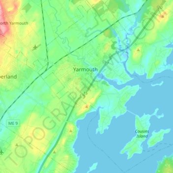
Name: Yarmouth topographic map, elevation, terrain.
Location: Yarmouth, Cumberland County, Maine, 04096, United States (43.73828 -70.22775 43.84294 -70.08398)
Average elevation: 82 ft
Minimum elevation: -10 ft
Maximum elevation: 377 ft
Cumberland County trails, hiking, mountain biking, running and outdoor activities
Other topographic maps
Click on a map to view its topography, its elevation and its terrain.
Cliff Island
United States > Maine > Cumberland County > Portland > Cliff Island
Average elevation: 3 ft