
Thank you for supporting this site ❤️
Make a donation
Make a donation
Gear up for your next adventure:
As an Amazon Associate, this site earns from qualifying purchases at no extra cost to you.
Điện Biên Phủ topographic map
Click on the map to display elevation.
Thank you for supporting this site ❤️
Make a donation
Make a donation
Gear up for your next adventure:
As an Amazon Associate, this site earns from qualifying purchases at no extra cost to you.
About this map
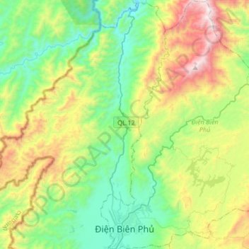
Name: Điện Biên Phủ topographic map, elevation, terrain.
Location: Điện Biên Phủ, Điện Biên Province, Vietnam (21.36646 102.99298 21.61489 103.18684)
Average elevation: 2,930 ft
Minimum elevation: 1,240 ft
Maximum elevation: 6,568 ft
Thank you for supporting this site ❤️
Make a donation
Make a donation
Gear up for your next adventure:
As an Amazon Associate, this site earns from qualifying purchases at no extra cost to you.
Other topographic maps
Click on a map to view its topography, its elevation and its terrain.
Bản Mường Nhé
Vietnam > Điện Biên Province > Mường Nhé District > Muong Nhe
Average elevation: 1,929 ft