
Clifton topographic map
Interactive map
Click on the map to display elevation.
About this map
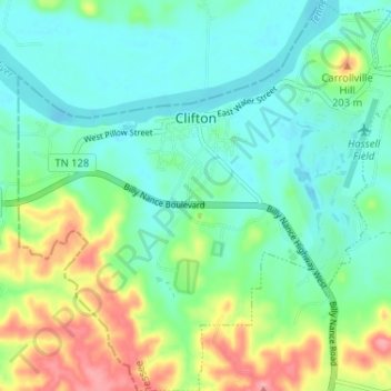
Name: Clifton topographic map, elevation, terrain.
Average elevation: 459 ft
Minimum elevation: 351 ft
Maximum elevation: 728 ft
Other topographic maps
Click on a map to view its topography, its elevation and its terrain.
Leatherwood
United States > Tennessee > Wayne County
Leatherwood, Wayne County, Middle Tennessee, Tennessee, United States
Average elevation: 650 ft
Lutts
United States > Tennessee > Wayne County
Lutts, Wayne County, Tennessee, United States
Average elevation: 709 ft
Collinwood
United States > Tennessee > Wayne County > Collinwood > Collinwood
Collinwood, Wayne County, Tennessee, 38450, United States
Average elevation: 955 ft
Waynesboro
United States > Tennessee > Wayne County
Waynesboro, Wayne County, Middle Tennessee, Tennessee, United States
Average elevation: 837 ft