
Redmond topographic map
Interactive map
Click on the map to display elevation.
Redmond
The city encompasses 15.5 square miles (40 km2) and is on a plateau, at an elevation of 3,077 feet (938 m). Redmond is 15 miles (24 km) north of Bend—the county seat of Deschutes County—144 miles (232 km) from Portland, 129 miles (208 km) from Salem—the capital of Oregon—and 126 miles (203 km) from Eugene.
About this map
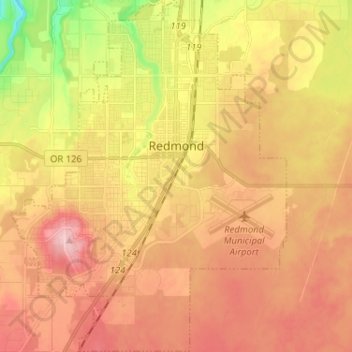
Name: Redmond topographic map, elevation, terrain.
Location: Redmond, Deschutes County, Oregon, 91156, United States (44.21857 -121.23475 44.31077 -121.13355)
Average elevation: 3,028 ft
Minimum elevation: 2,723 ft
Maximum elevation: 3,238 ft
Deschutes County trails, hiking, mountain biking, running and outdoor activities
Other topographic maps
Click on a map to view its topography, its elevation and its terrain.
Three Sisters
United States > Oregon > Deschutes County
The Three Sisters are closely spaced volcanic peaks in the U.S. state of Oregon. They are part of the Cascade Volcanic Arc, a segment of the Cascade Range in western North America extending from southern British Columbia through Washington and Oregon to Northern California. Each over 10,000 feet (3,000 meters)…
Average elevation: 8,287 ft