
Lookout Valley topographic map
Interactive map
Click on the map to display elevation.
About this map
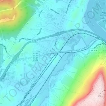
Name: Lookout Valley topographic map, elevation, terrain.
Average elevation: 909 ft
Minimum elevation: 627 ft
Maximum elevation: 2,152 ft
Hamilton County trails, hiking, mountain biking, running and outdoor activities
Other topographic maps
Click on a map to view its topography, its elevation and its terrain.
Tennesse Riverwalk
United States > Tennessee > Hamilton County > Chattanooga
Average elevation: 679 ft
Chickamauga and Chattanooga National Military Park
United States > Tennessee > Hamilton County > Chattanooga
Average elevation: 1,047 ft