Geolocate

Blue Hill topographic map

Interactive map

Click on the map to display elevation.

Blue Hill

According to the United States Census Bureau, the town has a total area of 86.57 square miles (224.22 km2), of which 62.48 square miles (161.82 km2) is land and 24.09 square miles (62.39 km2) is water. Located on Blue Hill Bay, the town is drained by Mill Brook. Blue Hill, elevation 940 feet (287 meters), is the town's highest point. Long Island, situated in Blue Hill Bay, is part of the town.

Wikipedia (CC-BY-SA 3.0)

About this map

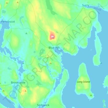
Name: Blue Hill topographic map, elevation, terrain.

Location: Blue Hill, Hancock County, Maine, United States (44.29745 -68.69667 44.50539 -68.46241)

Average elevation: 125 ft

Minimum elevation: -3 ft

Maximum elevation: 915 ft

Hancock County trails, hiking, mountain biking, running and outdoor activities

Other topographic maps

Click on a map to view its topography, its elevation and its terrain.

Salsbury Cove

United States > Maine > Hancock County > Bar Harbor

Average elevation: 49 ft

Little Deer Isle

United States > Maine > Hancock County > Deer Isle

Average elevation: 102 ft

Somesville

United States > Maine > Hancock County > Mount Desert

Average elevation: 72 ft

Sargentville

United States > Maine > Hancock County > Sedgwick

Average elevation: 98 ft

Atlantic

United States > Maine > Hancock County > Swan's Island

Average elevation: 36 ft

East Blue Hill

United States > Maine > Hancock County > Blue Hill

Average elevation: 98 ft

Harborside

United States > Maine > Hancock County > Brooksville

Average elevation: 43 ft

Minturn

United States > Maine > Hancock County > Swan's Island

Average elevation: 46 ft

East Orland

United States > Maine > Hancock County > Orland

Average elevation: 194 ft

Sunset

United States > Maine > Hancock County > Deer Isle

Average elevation: 46 ft

Birch Harbor

United States > Maine > Hancock County > Gouldsboro

Average elevation: 82 ft

Flat Island

United States > Maine > Hancock County > Deer Isle

Average elevation: 26 ft

Catamount

United States > Maine > Hancock County > Sullivan

Average elevation: 213 ft

Deer Island

United States > Maine > Hancock County > Ellsworth

Average elevation: 210 ft

Duck Mountain

United States > Maine > Hancock County

Average elevation: 781 ft

Sunshine

United States > Maine > Hancock County > Deer Isle

Average elevation: 10 ft

Fresh Meadow

United States > Maine > Hancock County > Bar Harbor

Average elevation: 56 ft

Somes Sound

United States > Maine > Hancock County > Mount Desert

Average elevation: 187 ft