Geolocate

Cleveland topographic map

Interactive map

Click on the map to display elevation.

About this map

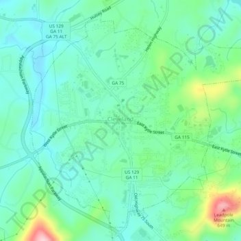
Name: Cleveland topographic map, elevation, terrain.

Location: Cleveland, White County, Georgia, 30528, United States (34.57994 -83.78088 34.61391 -83.73424)

Average elevation: 1,572 ft

Minimum elevation: 1,388 ft

Maximum elevation: 2,133 ft

Other topographic maps

Click on a map to view its topography, its elevation and its terrain.

Helen

United States > Georgia > White County

Helen, White County, Georgia, 30545, United States

Average elevation: 1,601 ft

Unicoi Lake

United States > Georgia > White County

Unicoi Lake, White County, Georgia, United States

Average elevation: 1,844 ft

Nacoochee

United States > Georgia > White County

Nacoochee, White County, Georgia, 30545, United States

Average elevation: 1,473 ft

Raven Cliff Falls

United States > Georgia > White County

Raven Cliff Falls, White County, Georgia, United States

Average elevation: 3,025 ft

Mossy Creek

United States > Georgia > White County

Mossy Creek, White County, Georgia, United States

Average elevation: 1,365 ft

Sautee

United States > Georgia > White County

Sautee, White County, Georgia, 30571, United States

Average elevation: 1,447 ft

Yonah Mountain

United States > Georgia > White County

Yonah Mountain, White County, Georgia, United States

Average elevation: 2,031 ft

Smithgall Woods State Park

United States > Georgia > White County

Smithgall Woods State Park, White County, Georgia, United States

Average elevation: 2,008 ft