
Pine topographic map
Interactive map
Click on the map to display elevation.
Pine
Pine and the adjacent community of Strawberry are rapidly growing vacation and retirement centers in north-central Arizona, below the Mogollon Rim. Pine's elevation is 5,448 feet (1,661 m), and the Pine post office was established in 1884.
About this map
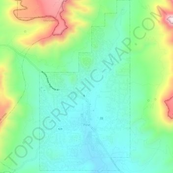
Name: Pine topographic map, elevation, terrain.
Location: Pine, Gila County, Arizona, United States (34.37097 -111.47143 34.41879 -111.44099)
Average elevation: 5,886 ft
Minimum elevation: 5,292 ft
Maximum elevation: 7,287 ft
Gila County trails, hiking, mountain biking, running and outdoor activities