Geolocate

West Branch topographic map

Interactive map

Click on the map to display elevation.

About this map

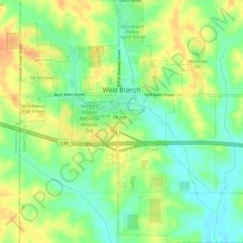
Name: West Branch topographic map, elevation, terrain.

Location: West Branch, Cedar County, Iowa, 52538, United States (41.64927 -91.36892 41.68544 -91.32042)

Average elevation: 748 ft

Minimum elevation: 689 ft

Maximum elevation: 807 ft

Other topographic maps

Click on a map to view its topography, its elevation and its terrain.

Lowden

United States > Iowa > Cedar County

Lowden, Cedar County, Iowa, United States

Average elevation: 745 ft

Cedar Valley

United States > Iowa > Cedar County

Cedar Valley, Cedar County, Iowa, United States

Average elevation: 751 ft

Rock Creek

United States > Iowa > Cedar County

Rock Creek, Cedar County, Iowa, 52772, United States

Average elevation: 771 ft

Clarence

United States > Iowa > Cedar County > Clarence

Clarence, Cedar County, Iowa, 52216, United States

Average elevation: 827 ft

Stanwood

United States > Iowa > Cedar County

Stanwood, Cedar County, Iowa, United States

Average elevation: 837 ft

Clarence

United States > Iowa > Cedar County

Clarence, Cedar County, Iowa, United States

Average elevation: 830 ft