
Chattogram topographic map
Interactive map
Click on the map to display elevation.


Chattogram
Chittagong lies at 22°20′06″N 91°49′57″E / 22.33500°N 91.83250°E / 22.33500; 91.83250. It straddles the coastal foothills of the Chittagong Hill Tracts in southeastern Bangladesh. The Karnaphuli River runs along the southern banks of the city, including its central business district. The river enters the Bay of Bengal in an estuary located 12 kilometres (7.5 mi) west of downtown Chittagong. Mount Sitakunda is the highest peak in Chittagong District, with an elevation of 351 metres (1,152 ft). Within the city itself, the highest peak is Batali Hill at 85.3 metres (280 ft). Chittagong has many lakes that were created under the Mughal rule. In 1924, an engineering team of the Assam Bengal Railway established the Foy's Lake.
About this map
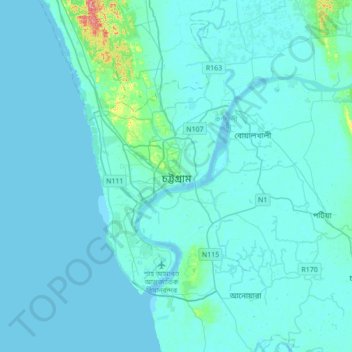
Name: Chattogram topographic map, elevation, terrain.
Average elevation: 20 ft
Minimum elevation: -7 ft
Maximum elevation: 331 ft
Other topographic maps
Click on a map to view its topography, its elevation and its terrain.