
Gadsden topographic map
Interactive map
Click on the map to display elevation.
About this map
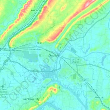
Name: Gadsden topographic map, elevation, terrain.
Location: Gadsden, Etowah County, Alabama, United States (33.94643 -86.11030 34.07934 -85.93461)
Average elevation: 617 ft
Minimum elevation: 492 ft
Maximum elevation: 1,227 ft
Etowah County trails, hiking, mountain biking, running and outdoor activities
Other topographic maps
Click on a map to view its topography, its elevation and its terrain.
Rainbow City
United States > Alabama > Etowah County > Rainbow City > Rainbow City
Average elevation: 584 ft