
Town of Duanesburg topographic map
Interactive map
Click on the map to display elevation.
Town of Duanesburg
The town consists of mostly wooded hills up to an elevation of approximately 1,400 feet (430 m) above sea level. Most of the town was cleared farmland until the late 20th century. After this point forests grew to cover 60% of the total land area with a canopy higher than 40 feet (12 m). The forest is primary composed of poplar, hemlock, oak, maple, white pine, and balsam fir. The maximum tree heights in Duanesburg are approximately 80 feet (24 m) high.
About this map
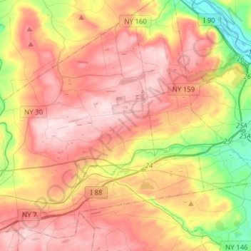
Name: Town of Duanesburg topographic map, elevation, terrain.
Average elevation: 906 ft
Minimum elevation: 220 ft
Maximum elevation: 1,470 ft
Schenectady County trails, hiking, mountain biking, running and outdoor activities
Other topographic maps
Click on a map to view its topography, its elevation and its terrain.
Rotterdam Junction
United States > New York > Schenectady County > Town of Rotterdam
Average elevation: 531 ft
Stoodley Corners
United States > New York > Schenectady County > East Glenville
Average elevation: 351 ft
Lower Corners
United States > New York > Schenectady County > Town of Glenville
Average elevation: 673 ft
Pattersonville
United States > New York > Schenectady County > Town of Rotterdam
Average elevation: 502 ft
Bellevue
United States > New York > Schenectady County > City of Schenectady > Bellevue
Average elevation: 308 ft
The Stockade
United States > New York > Schenectady County > Schenectady > The Stockade
Average elevation: 269 ft
Stanford Heights
United States > New York > Schenectady County > Town of Niskayuna
Average elevation: 348 ft