
Sarpang District topographic map
Interactive map
Click on the map to display elevation.
About this map
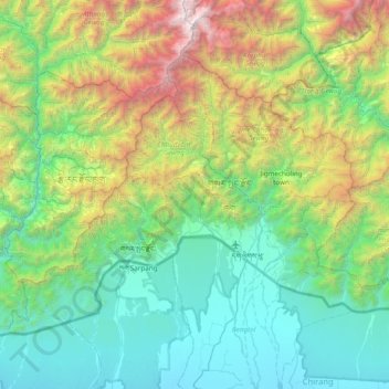
Name: Sarpang District topographic map, elevation, terrain.
Location: Sarpang District, Bhutan (26.72981 90.00933 27.22166 90.77709)
Average elevation: 3,855 ft
Minimum elevation: 240 ft
Maximum elevation: 15,741 ft
Other topographic maps
Click on a map to view its topography, its elevation and its terrain.
Trongsa
Bhutan > Trongsa District > Nubi Gewog > Bagochen Boolingpang Ueling
Average elevation: 8,481 ft
Gangkhar Puensum
Bhutan > Gasa District > Lunana Gewogs > Thangza_Toenchoe
Average elevation: 21,706 ft
Rangjung
Bhutan > Trashigang District > Shongphu Gewog > Chhangmi_Rangjoong
Average elevation: 5,427 ft
Jakar
Bhutan > Bumthang District > Chhoekhor Gewog > Dawathang_Dorjibi_ Kashingtsawa
Average elevation: 9,672 ft
Thimphu
Bhutan > Thimphu District > Chang Gewog
The city extends in a north–south direction on the west bank of the valley formed by the Wang Chhu, which flows out into India as the Raidāk River. Thimphu is the fifth highest capital in the world by altitude and ranges in altitude from 2,248 metres (7,375 feet) to 2,648 metres (8,688 feet). Unusually for…
Average elevation: 10,240 ft
Wet Land
Bhutan > Trongsa District > Nubi Gewog > Bagochen Boolingpang Ueling
Average elevation: 7,201 ft
Tsimasham
Bhutan > Chukha District > Bjagchhog Gewog > Tsimakha Tsimashysham
Average elevation: 8,241 ft
Thimphu
Bhutan > Thimphu District > Chang Gewog
The city extends in a north–south direction on the west bank of the valley formed by the Wang Chhu, which flows out into India as the Raidāk River. Thimphu is the fifth highest capital in the world by altitude and ranges in altitude from 2,248 metres (7,375 feet) to 2,648 metres (8,688 feet).[2][3][4][5][6]…
Average elevation: 10,240 ft
Chhusemu Chu
Bhutan > Wangdue Phodrang District > Saephu Gewog > Booso Zeri
Average elevation: 10,266 ft
Wangdue Phodrang Dzongkhag
Bhutan > Wangdue Phodrang District > Wangdue Phodrang Dzongkhag
Average elevation: 10,335 ft
Gangkhar Puensum
Bhutan > Gasa District > Lunana Gewogs > Thangza_Toenchoe
Average elevation: 21,706 ft
Border Bhutan - China
Bhutan > Trashigang District > Pusa_Tenmang Chiwogs
Average elevation: 11,319 ft
Gomtu
Bhutan > Samtse District > Phuentshogpelri Gewog > Jangchhogling Lachhungthang
Average elevation: 1,286 ft
Wamrong
Bhutan > Trashigang District > Thrimshing Gewog > Ramchongma_Yemkhar Chiwogs > Wamrong
Average elevation: 6,266 ft
Phongmey
Bhutan > Trashigang District > Phongmed Gewog > Thong-Rong Chiwogs > Phongmey
Average elevation: 6,877 ft