
Northport topographic map
Interactive map
Click on the map to display elevation.
About this map
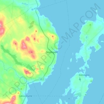
Name: Northport topographic map, elevation, terrain.
Location: Northport, Waldo County, Maine, United States (44.27091 -69.08234 44.40508 -68.92961)
Average elevation: 121 ft
Minimum elevation: -7 ft
Maximum elevation: 784 ft
Waldo County trails, hiking, mountain biking, running and outdoor activities
Other topographic maps
Click on a map to view its topography, its elevation and its terrain.