Geolocate

Abbot topographic map

Click on the map to display elevation.

About this map

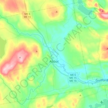
Name: Abbot topographic map, elevation, terrain.

Location: Abbot, Piscataquis County, Maine, 04406, United States (45.14501 -69.55060 45.24324 -69.40209)

Average elevation: 581 ft

Minimum elevation: 367 ft

Maximum elevation: 1,010 ft

Piscataquis County trails, hiking, mountain biking, running and outdoor activities

Other topographic maps

Click on a map to view its topography, its elevation and its terrain.

Kokadjo

United States > Maine > Piscataquis County

Average elevation: 1,322 ft

Shirley Mills

United States > Maine > Piscataquis County > Shirley

Average elevation: 1,158 ft

Ebeemee Mountain

United States > Maine > Piscataquis County

Average elevation: 1,220 ft

Schoodic

United States > Maine > Piscataquis County

Average elevation: 525 ft

Gear up for your next adventure:

⛑️Personal Locator Beacon - Safety beacon for emergencies
🌲Outdoor Survival Books - Best books on survival skills
🧦Merino Wool Socks - Moisture-wicking, blister-preventing socks for long treks
🔌USB Car Charger - Car charger for on‑the‑go power needs
🌡️Handheld Weather Meters - Measure wind, temp, and pressure for safe mountain travel

As an Amazon Associate, this site earns from qualifying purchases at no extra cost to you.