
Thank you for supporting this site ❤️
Make a donation
Make a donation
Gear up for your next adventure:
As an Amazon Associate, this site earns from qualifying purchases at no extra cost to you.
Heer-Agimont topographic map
Click on the map to display elevation.
Thank you for supporting this site ❤️
Make a donation
Make a donation
Gear up for your next adventure:
As an Amazon Associate, this site earns from qualifying purchases at no extra cost to you.
About this map
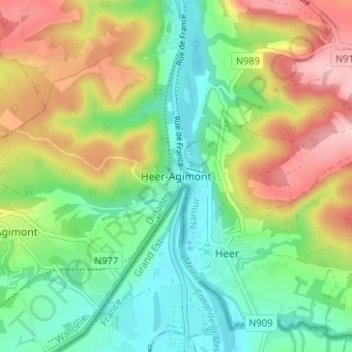
Name: Heer-Agimont topographic map, elevation, terrain.
Location: Heer-Agimont, Hastière, Dinant, Namen, Wallonië, 5543, België (50.15050 4.80266 50.19050 4.84266)
Average elevation: 548 ft
Minimum elevation: 305 ft
Maximum elevation: 932 ft
Thank you for supporting this site ❤️
Make a donation
Make a donation
Gear up for your next adventure:
As an Amazon Associate, this site earns from qualifying purchases at no extra cost to you.