Geolocate

Coshocton topographic map

Click on the map to display elevation.

About this map

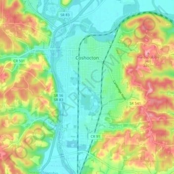
Name: Coshocton topographic map, elevation, terrain.

Location: Coshocton, Coshocton County, Ohio, 43812, United States (40.23410 -81.89436 40.28853 -81.81135)

Average elevation: 879 ft

Minimum elevation: 728 ft

Maximum elevation: 1,119 ft

Coshocton County trails, hiking, mountain biking, running and outdoor activities

Other topographic maps

Click on a map to view its topography, its elevation and its terrain.

Spring Mountain

United States > Ohio > Coshocton County

Average elevation: 1,070 ft

Blissfield

United States > Ohio > Coshocton County

Average elevation: 889 ft

New Moscow

United States > Ohio > Coshocton County

Average elevation: 935 ft

Walhonding

United States > Ohio > Coshocton County

Average elevation: 994 ft

Fresno

United States > Ohio > Coshocton County

Average elevation: 899 ft

Gear up for your next adventure:

💧Water Purification System - Clean water on the trail with reliable purifiers
Backpacking Tents - Weight-optimized shelters for multi-day topographic surveys
Solar GPS Watches - Advanced multisport watches with built-in topographic maps
🧴Hand Sanitizer - Keep hands clean while hiking
🪶Camp Gear Gift Set - Perfect gift bundle for outdoor fans

As an Amazon Associate, this site earns from qualifying purchases at no extra cost to you.