
Cradle Mountain topographic map
Interactive map
Click on the map to display elevation.
About this map
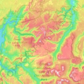
Name: Cradle Mountain topographic map, elevation, terrain.
Location: Cradle Mountain, Kentish, Tasmania, Australia (-41.88644 145.66933 -41.56801 146.20159)
Average elevation: 2,493 ft
Minimum elevation: 709 ft
Maximum elevation: 5,230 ft
Other topographic maps
Click on a map to view its topography, its elevation and its terrain.
Mount Wellington
"... In many parts the Eucalypti grew to a great size, and composed a noble forest. In some of the dampest ravines, tree-ferns flourished in an extraordinary manner; I saw one which must have been at least twenty feet high to the base of the fronds, and was in girth exactly six feet. The fronds forming the…
Average elevation: 3,087 ft