New Hartford topographic map
Interactive map
Click on the map to display elevation.
About this map
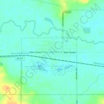
Name: New Hartford topographic map, elevation, terrain.
Location: New Hartford, Butler County, Iowa, United States (42.56313 -92.63295 42.57060 -92.61349)
Average elevation: 906 ft
Minimum elevation: 876 ft
Maximum elevation: 994 ft
Other topographic maps
Click on a map to view its topography, its elevation and its terrain.
Parkersburg
United States > Iowa > Butler County
Parkersburg, Butler County, Iowa, United States
Average elevation: 968 ft
Austinville
United States > Iowa > Butler County
Austinville, Butler County, Iowa, 50608, United States
Average elevation: 1,024 ft
Greene
United States > Iowa > Butler County
Greene, Butler County, Iowa, United States
Average elevation: 988 ft
Shell Rock
United States > Iowa > Butler County
Shell Rock, Butler County, Iowa, United States
Average elevation: 915 ft
Aplington
United States > Iowa > Butler County
Aplington, Butler County, Iowa, United States
Average elevation: 991 ft
Aredale
United States > Iowa > Butler County
Aredale, Butler County, Iowa, United States
Average elevation: 1,033 ft
Allison
United States > Iowa > Butler County
Allison, Butler County, Iowa, United States
Average elevation: 1,040 ft
Kesley
United States > Iowa > Butler County
Kesley, Butler County, Iowa, 50649, United States
Average elevation: 1,001 ft
Clarksville
United States > Iowa > Butler County
Clarksville, Butler County, Iowa, United States
Average elevation: 935 ft
Dumont
United States > Iowa > Butler County
Dumont, Butler County, Iowa, United States
Average elevation: 988 ft
Bristow
United States > Iowa > Butler County
Bristow, Butler County, Iowa, United States
Average elevation: 1,024 ft