
Sherman Square topographic map
Click on the map to display elevation.
About this map
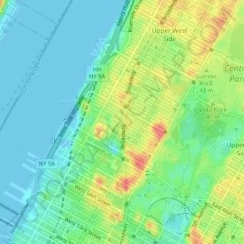
Name: Sherman Square topographic map, elevation, terrain.
Average elevation: 72 ft
Minimum elevation: -3 ft
Maximum elevation: 213 ft
New York County trails, hiking, mountain biking, running and outdoor activities
Other topographic maps
Click on a map to view its topography, its elevation and its terrain.
Highbridge Park
United States > New York > New York County > New York
The north and south wings respectively contain the women's and men's locker rooms and are nearly identical. Both have nine windows separated by eight brick pilasters. The stone capitals of the pilasters line up with the lintels of the windows. Ramps lead from the extreme ends of each wing. The ground slopes…
Average elevation: 98 ft
Fort Tryon Park
United States > New York > New York County > New York
In preparation for converting the land into a city park, Rockefeller hired the Olmsted Brothers firm, particularly Frederick Law Olmsted Jr., son of the designer of Central Park. Olmsted's design capitalized on the topography to reveal sweeping vistas of the Hudson River and the Palisades. Olmsted Jr. was…
Average elevation: 66 ft