
Knoxville topographic map
Interactive map
Click on the map to display elevation.
About this map
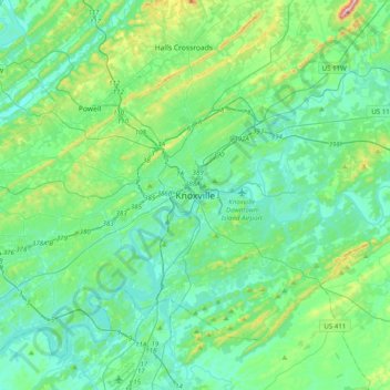
Name: Knoxville topographic map, elevation, terrain.
Location: Knoxville, Knox County, Tennessee, 37996-4134, United States (35.80039 -84.08103 36.12039 -83.76103)
Average elevation: 997 ft
Minimum elevation: 761 ft
Maximum elevation: 2,024 ft
Knox County trails, hiking, mountain biking, running and outdoor activities
Other topographic maps
Click on a map to view its topography, its elevation and its terrain.