Geolocate

Goodrich topographic map

Interactive map

Click on the map to display elevation.

About this map

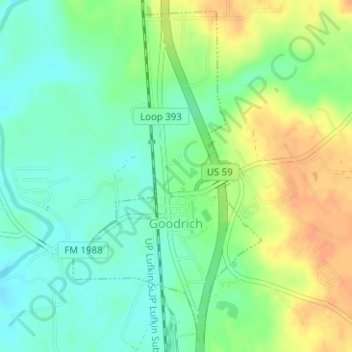
Name: Goodrich topographic map, elevation, terrain.

Location: Goodrich, Polk County, Texas, United States (30.59649 -94.95576 30.62177 -94.93893)

Average elevation: 125 ft

Minimum elevation: 72 ft

Maximum elevation: 190 ft

Polk County trails, hiking, mountain biking, running and outdoor activities

Other topographic maps

Click on a map to view its topography, its elevation and its terrain.

Segno

United States > Texas > Polk County

Average elevation: 197 ft

West Livingston

United States > Texas > Polk County

Average elevation: 138 ft

Blanchard

United States > Texas > Polk County

Average elevation: 154 ft

Dallardsville

United States > Texas > Polk County > Dallardsville

Average elevation: 249 ft

Asia

United States > Texas > Polk County > Asia

Average elevation: 262 ft

Tobacco Patch

United States > Texas > Polk County > Tobacco Patch

Average elevation: 141 ft