
Petal topographic map
Interactive map
Click on the map to display elevation.
About this map
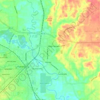
Name: Petal topographic map, elevation, terrain.
Location: Petal, Forrest County, Mississippi, 39465, United States (31.31030 -89.28618 31.37589 -89.17334)
Average elevation: 187 ft
Minimum elevation: 105 ft
Maximum elevation: 305 ft
Forrest County trails, hiking, mountain biking, running and outdoor activities
Other topographic maps
Click on a map to view its topography, its elevation and its terrain.
Bell-Sandifer Leisure Park
United States > Mississippi > Forrest County > Hattiesburg
Average elevation: 161 ft