
Make a donation
Gear up for your next adventure:
As an Amazon Associate, this site earns from qualifying purchases at no extra cost to you.
Pilot Knob topographic map
Click on the map to display elevation.
Make a donation
Gear up for your next adventure:
As an Amazon Associate, this site earns from qualifying purchases at no extra cost to you.
About this map
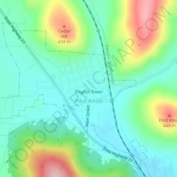
Name: Pilot Knob topographic map, elevation, terrain.
Location: Pilot Knob, Iron County, Missouri, 63663, United States (37.61291 -90.65898 37.63307 -90.63130)
Average elevation: 1,096 ft
Minimum elevation: 906 ft
Maximum elevation: 1,539 ft
Iron County trails, hiking, mountain biking, running and outdoor activities
Make a donation
Gear up for your next adventure:
As an Amazon Associate, this site earns from qualifying purchases at no extra cost to you.
Other topographic maps
Click on a map to view its topography, its elevation and its terrain.
Elephant Rocks State Park
United States > Missouri > Iron County > Graniteville
Average elevation: 1,227 ft