
Make a donation
Gear up for your next adventure:
As an Amazon Associate, this site earns from qualifying purchases at no extra cost to you.
Schuylkill River topographic map
Click on the map to display elevation.
Make a donation
Gear up for your next adventure:
As an Amazon Associate, this site earns from qualifying purchases at no extra cost to you.
About this map
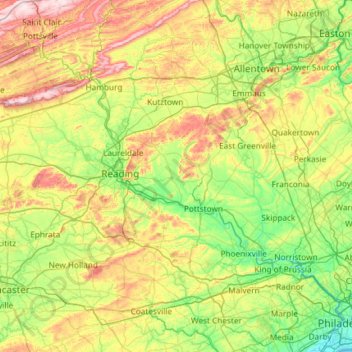
Name: Schuylkill River topographic map, elevation, terrain.
Average elevation: 515 ft
Minimum elevation: -7 ft
Maximum elevation: 1,772 ft
Make a donation
Gear up for your next adventure:
As an Amazon Associate, this site earns from qualifying purchases at no extra cost to you.
Other topographic maps
Click on a map to view its topography, its elevation and its terrain.
Gettysburg National Military Park
United States of America > Pennsylvania > Gettysburg
Average elevation: 545 ft
Make a donation
Gear up for your next adventure:
As an Amazon Associate, this site earns from qualifying purchases at no extra cost to you.
Twin Churchs
United States of America > Pennsylvania > Sandycreek Township > Twin Churchs
Average elevation: 1,447 ft