
South Kesteven topographic map
Interactive map
Click on the map to display elevation.
About this map
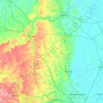
Name: South Kesteven topographic map, elevation, terrain.
Location: South Kesteven, Lincolnshire, England, United Kingdom (52.64022 -0.80432 53.05995 -0.21251)
Average elevation: 174 ft
Minimum elevation: -3 ft
Maximum elevation: 715 ft
Other topographic maps
Click on a map to view its topography, its elevation and its terrain.
Moulton Chapel
United Kingdom > England > Lincolnshire > South Holland > Moulton Chapel
Average elevation: 10 ft
Saltfleetby St Peter
United Kingdom > England > Lincolnshire > East Lindsey > Saltfleetby St Peter
Average elevation: 10 ft