
Kwun Tong District topographic map
Interactive map
Click on the map to display elevation.
About this map
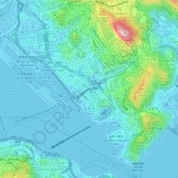
Name: Kwun Tong District topographic map, elevation, terrain.
Location: Kwun Tong District, Hong Kong, PRC (22.28272 114.20172 22.33484 114.24565)
Average elevation: 200 ft
Minimum elevation: -75 ft
Maximum elevation: 1,309 ft
Other topographic maps
Click on a map to view its topography, its elevation and its terrain.