
North Hero topographic map
Interactive map
Click on the map to display elevation.
About this map
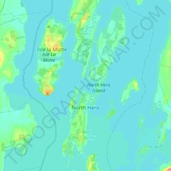
Name: North Hero topographic map, elevation, terrain.
Location: North Hero, Grand Isle County, Vermont, 05474, United States (44.75124 -73.35216 44.92792 -73.19128)
Average elevation: 105 ft
Minimum elevation: 89 ft
Maximum elevation: 285 ft
Grand Isle County trails, hiking, mountain biking, running and outdoor activities
Other topographic maps
Click on a map to view its topography, its elevation and its terrain.