
Jim Thorpe topographic map
Interactive map
Click on the map to display elevation.
Jim Thorpe
In the deeps of the geologic timescale the two shorelines of the Lehigh River occupied by the 19th-century towns of Mauch Chunk and East Mauch Chunk were situated on the bottom of an ancient river-fed tarn, a mountain lake which filled the valley on the west bank and covered the relative flatlands on the east bank. The muddy bottom of that high tarn (the range then rivaling the Himalayas in size), where the waters pooled at a lower elevation amongst the twisted folds of four near-parallel ridgelines, created a level region whose settlements became the relatively flat lands on either bank of the Lehigh. The ridgelines, which run east-northeast to west-southwest, are (from north to south) Broad, Nesquehoning, Pisgah, and Mauch Chunk ridges (or Mountains)—each of which runs over 15 miles (24.1 km) west to the gaps cut by the Schuylkill River.
About this map
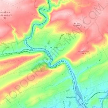
Name: Jim Thorpe topographic map, elevation, terrain.
Average elevation: 1,073 ft
Minimum elevation: 443 ft
Maximum elevation: 1,775 ft
Carbon County trails, hiking, mountain biking, running and outdoor activities
Other topographic maps
Click on a map to view its topography, its elevation and its terrain.
Hickory Run State Park
United States > Pennsylvania > Carbon County > Kidder Township
Average elevation: 1,545 ft
Beltzville State Park - Parking Lot B
United States > Pennsylvania > Carbon County > Lehighton
Average elevation: 728 ft
Albrightsville
United States > Pennsylvania > Carbon County > Kidder Township
Average elevation: 1,634 ft
Albrightsville
United States > Pennsylvania > Carbon County > Kidder Township
Average elevation: 1,634 ft
Lake Harmony
United States > Pennsylvania > Carbon County > Kidder Township > Lake Harmony
Average elevation: 1,808 ft
Germans
United States > Pennsylvania > Carbon County > East Penn Township > Germans
Average elevation: 781 ft