
Charlestown topographic map
Interactive map
Click on the map to display elevation.
About this map
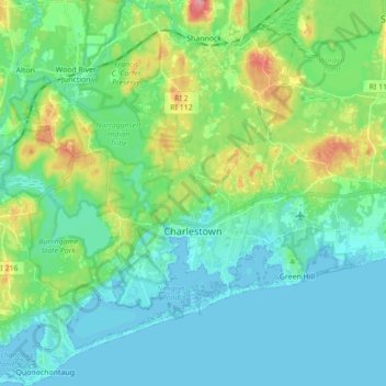
Name: Charlestown topographic map, elevation, terrain.
Average elevation: 72 ft
Minimum elevation: -10 ft
Maximum elevation: 302 ft
South County trails, hiking, mountain biking, running and outdoor activities
Other topographic maps
Click on a map to view its topography, its elevation and its terrain.
Wakefield
United States > Rhode Island > South County > South Kingstown > Wakefield
Average elevation: 75 ft
Saunderstown
United States > Rhode Island > South County > North Kingstown > Saunderstown
Average elevation: 46 ft