
Montpelier topographic map
Interactive map
Click on the map to display elevation.
Montpelier
Montpelier is located in the north-central area of Vermont. The city center is a flat clay zone (elevation 520 ft/158 m), surrounded by hills and granite ledges. Towne Hill runs in a 2-mile (3.2 km) ridge (~900 ft/275 m) along the northern edge of the city.
About this map
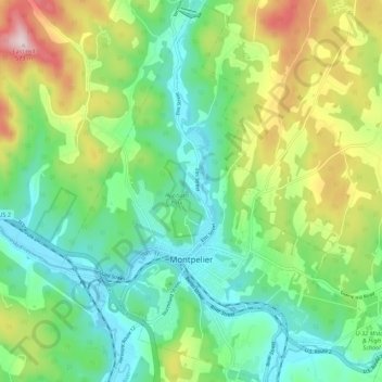
Name: Montpelier topographic map, elevation, terrain.
Location: Montpelier, Washington County, Vermont, 05602, United States (44.23492 -72.61245 44.31331 -72.52509)
Average elevation: 932 ft
Minimum elevation: 499 ft
Maximum elevation: 1,850 ft
Washington County trails, hiking, mountain biking, running and outdoor activities
Other topographic maps
Click on a map to view its topography, its elevation and its terrain.
Northfield Center
United States > Vermont > Washington County > Northfield
Average elevation: 1,119 ft
South Cabot
United States > Vermont > Washington County > Cabot > South Cabot
Average elevation: 1,575 ft