
San Marcos topographic map
Interactive map
Click on the map to display elevation.
San Marcos
San Marcos is characterized by its diverse topography, which includes rolling hills, lush riverbanks, and scenic limestone outcroppings. The city is situated at an elevation of approximately 600 feet above sea level, providing a backdrop of gently undulating terrain that slopes towards the banks of the San Marcos River. This river, one of the longest spring-fed rivers in the country, weaves through the landscape, creating rich riparian habitats and offering a natural corridor for both wildlife and recreational activities. The surrounding hills are dotted with oak and cedar trees, contributing to the region’s picturesque views and offering numerous opportunities for hiking and outdoor exploration. Overall, the interplay of water and elevated landforms creates a dynamic and inviting environment in San Marcos.
About this map
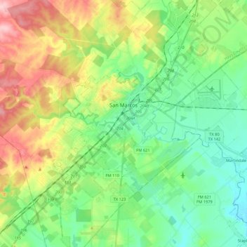
Name: San Marcos topographic map, elevation, terrain.
Location: San Marcos, Hays County, Texas, 78666, United States (29.77658 -98.01213 29.96059 -97.84196)
Average elevation: 682 ft
Minimum elevation: 486 ft
Maximum elevation: 1,060 ft
Hays County trails, hiking, mountain biking, running and outdoor activities
Other topographic maps
Click on a map to view its topography, its elevation and its terrain.