
Lancing topographic map
Interactive map
Click on the map to display elevation.
About this map
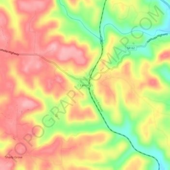
Name: Lancing topographic map, elevation, terrain.
Average elevation: 1,283 ft
Minimum elevation: 1,020 ft
Maximum elevation: 1,463 ft
Morgan County trails, hiking, mountain biking, running and outdoor activities
Other topographic maps
Click on a map to view its topography, its elevation and its terrain.
Frozen Head State Park
United States > Tennessee > Morgan County
Frozen Head State Park consists of approximately 24,000 acres (97 km2), all but 330 acres (1.3 km2) of which is classified as a state natural area. The terrain varies between 1,300 ft (400 m) to over 3,000 ft (910 m) with 14 peaks at or over 3,000 feet (910 m). Frozen Head, the park's namesake, is the highest…
Average elevation: 1,900 ft