
Waldport topographic map
Interactive map
Click on the map to display elevation.
About this map
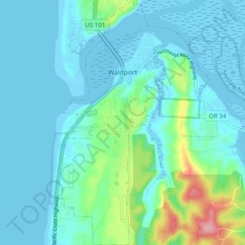
Name: Waldport topographic map, elevation, terrain.
Location: Waldport, Lincoln County, Oregon, 97394, United States (44.39259 -124.08478 44.44127 -124.04081)
Average elevation: 69 ft
Minimum elevation: -30 ft
Maximum elevation: 430 ft
Lincoln County trails, hiking, mountain biking, running and outdoor activities
Other topographic maps
Click on a map to view its topography, its elevation and its terrain.