Geolocate

Cascadia topographic map

Interactive map

Click on the map to display elevation.

About this map

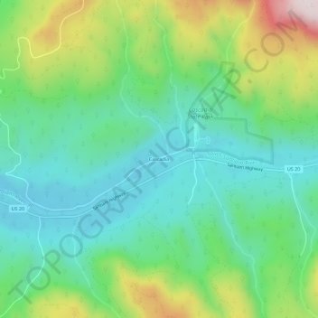
Name: Cascadia topographic map, elevation, terrain.

Location: Cascadia, Linn County, Oregon, 97329, United States (44.37729 -122.50724 44.41729 -122.46724)

Average elevation: 1,362 ft

Minimum elevation: 771 ft

Maximum elevation: 2,740 ft

Linn County trails, hiking, mountain biking, running and outdoor activities

Other topographic maps

Click on a map to view its topography, its elevation and its terrain.

Tangent

United States > Oregon > Linn County

Average elevation: 246 ft

Millersburg

United States > Oregon > Linn County

Average elevation: 240 ft

Menagerie Wilderness

United States > Oregon > Linn County

Average elevation: 2,687 ft

Scio

United States > Oregon > Linn County

Average elevation: 348 ft

Mill City

United States > Oregon > Linn County

Average elevation: 958 ft

Brownsville

United States > Oregon > Linn County

Average elevation: 381 ft

Sodaville

United States > Oregon > Linn County > Sodaville

Average elevation: 551 ft