
Ankeny topographic map
Interactive map
Click on the map to display elevation.
Ankeny
Like most of Polk County, Iowa, Ankeny exists at the bottom area of the Des Moines Lobe, a topographical landscape area, in an area known as the Bemis Advance. The Lobe was formed during the Wisconsin glaciation leaving significant deposits resulting in an area with low relief.
About this map
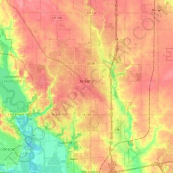
Name: Ankeny topographic map, elevation, terrain.
Location: Ankeny, Polk County, Iowa, United States (41.65213 -93.67277 41.80218 -93.54144)
Average elevation: 932 ft
Minimum elevation: 778 ft
Maximum elevation: 1,030 ft
Polk County trails, hiking, mountain biking, running and outdoor activities
Other topographic maps
Click on a map to view its topography, its elevation and its terrain.