
Cape May County topographic map
Interactive map
Click on the map to display elevation.
Cape May County
Cape May County is 29 mi (47 km) long and 15 mi (24 km) at its widest. According to the 2010 Census, the county had a total area of 620.42 square miles (1,606.9 km2), including 251.42 square miles (651.2 km2) of land (40.5%) and 368.99 square miles (955.7 km2) of water (59.5%). The county is located about 150 mi (240 km) south of New York City, 80 mi (130 km) southeast of Philadelphia, and 150 mi (240 km) east of Washington, D.C. To the south and east of the county is the Atlantic Ocean. The location near water provides milder temperatures than surrounding areas, as well as a continuous breeze, which contribute to the area's tourism-driven economy. Sea level along the coast is the lowest point. The highest elevation is found at three areas in Belleplain State Forest in the county's northern corner, which are approximately 60 ft (18 m) above sea level.
About this map
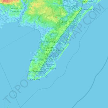
Name: Cape May County topographic map, elevation, terrain.
Location: Cape May County, New Jersey, United States (38.79113 -75.17705 39.32436 -74.49294)
Average elevation: 3 ft
Minimum elevation: -16 ft
Maximum elevation: 95 ft
New Jersey trails, hiking, mountain biking, running and outdoor activities
Other topographic maps
Click on a map to view its topography, its elevation and its terrain.
Elmer B Boyd Park
United States > New Jersey > Middlesex County > New Brunswick > Feaster Park
Average elevation: 72 ft
Hendrickson Corners
United States > New Jersey > Monmouth County > Middletown Township
Average elevation: 72 ft
Emleys Hill
United States > New Jersey > Monmouth County > Upper Freehold Township
Average elevation: 151 ft
Hendrickson Corners
United States > New Jersey > Monmouth County > Middletown Township
Average elevation: 72 ft
Hillside Terrace
United States > New Jersey > Mercer County > Robbinsville Township
Average elevation: 115 ft
Marlboro
United States > New Jersey > Burlington County > Evesham Township > Marlton
Average elevation: 85 ft
Burlington Heights
United States > New Jersey > Monmouth County > Freehold Township
Average elevation: 154 ft
Downs Farms
United States > New Jersey > Camden County > Cherry Hill Township
Average elevation: 79 ft
High Rock Mountain
United States > New Jersey > Warren County > White Township
Average elevation: 620 ft
Marion
United States > New Jersey > Hudson County > Jersey City > Journal Square
Average elevation: 39 ft
Schooleys Mountain
United States > New Jersey > Morris County > Washington Township
Average elevation: 961 ft
Alloway Township
United States > New Jersey > Salem County > Alloway Township
Average elevation: 46 ft
West Keansburg
United States > New Jersey > Monmouth County > Hazlet Township
Average elevation: 13 ft
Bearfort Mountain
United States > New Jersey > Passaic County > West Milford
At an elevation of 1,331 feet (406 m) the ridge is the site of a 68 feet (21 m) high fire lookout tower built by the New Jersey Forest Fire Service.
Average elevation: 1,161 ft
Timbuctoo
United States > New Jersey > Burlington County > Westampton Township
Average elevation: 46 ft
Fieldville
United States > New Jersey > Middlesex County > Piscataway Township
Average elevation: 56 ft
Calais Crossroads
United States > New Jersey > Morris County > Randolph Township
Average elevation: 932 ft
Sand Hills
United States > New Jersey > Middlesex County > Woodbridge Township > Fords
Average elevation: 79 ft
Middlesex Downs
United States > New Jersey > Middlesex County > Monroe Township
Average elevation: 108 ft
Mantua Grove
United States > New Jersey > Gloucester County > West Deptford Township
Average elevation: 36 ft
Jobstown
United States > New Jersey > Burlington County > Springfield Township
Average elevation: 72 ft
Parkville
United States > New Jersey > Gloucester County > West Deptford Township
Average elevation: 46 ft
Ringoes
United States > New Jersey > Hunterdon County > East Amwell Township
Average elevation: 246 ft
Creesville
United States > New Jersey > Gloucester County > Washington Township
Average elevation: 105 ft
West Creek
United States > New Jersey > Cumberland County > Maurice River Township
Average elevation: 16 ft
Cupsaw Lake
United States > New Jersey > Passaic County > Ringwood > Erskine Lakes
Average elevation: 515 ft
Washington Valley
United States > New Jersey > Morris County > Morris Township
Average elevation: 499 ft
Quakertown
United States > New Jersey > Hunterdon County > Franklin Township
Average elevation: 571 ft
Chimney Rock
United States > New Jersey > Somerset County > Bridgewater Township
Average elevation: 184 ft
Andrews
United States > New Jersey > Camden County > Winslow Township > Sicklerville
Average elevation: 131 ft
Mount Freedom
United States > New Jersey > Morris County > Randolph Township
Average elevation: 883 ft