
Make a donation
Gear up for your next adventure:
As an Amazon Associate, this site earns from qualifying purchases at no extra cost to you.
Sisters topographic map
Click on the map to display elevation.
Make a donation
Gear up for your next adventure:
As an Amazon Associate, this site earns from qualifying purchases at no extra cost to you.
About this map
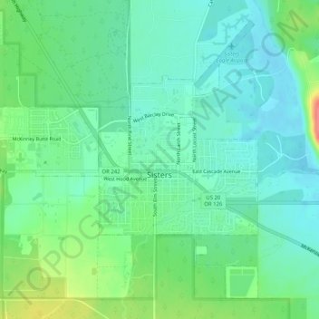
Name: Sisters topographic map, elevation, terrain.
Location: Sisters, Deschutes County, Oregon, 97759, United States (44.27687 -121.58416 44.30842 -121.53360)
Average elevation: 3,192 ft
Minimum elevation: 3,130 ft
Maximum elevation: 3,350 ft
Deschutes County trails, hiking, mountain biking, running and outdoor activities
Make a donation
Gear up for your next adventure:
As an Amazon Associate, this site earns from qualifying purchases at no extra cost to you.
Other topographic maps
Click on a map to view its topography, its elevation and its terrain.
Pilot Butte
United States > Oregon > Deschutes County > Bend
The 114.22-acre (46.22-hectare) Pilot Butte State Scenic Viewpoint, presented as a gift to the State of Oregon in 1928, is a Bend icon. Pilot Butte itself is a popular hiking destination with two trails to the summit, each gaining about 490 ft (150 m) in elevation. There is also a 1.8-mile (2.9 km) trail…
Average elevation: 3,648 ft
South Sister
United States > Oregon > Deschutes County
The Three Sisters are closely spaced volcanic peaks in the U.S. state of Oregon. They are part of the Cascade Volcanic Arc, a segment of the Cascade Range in western North America extending from southern British Columbia through Washington and Oregon to Northern California. Each over 10,000 feet (3,000 meters)…
Average elevation: 8,642 ft
Mount Bachelor
United States > Oregon > Deschutes County
Mount Bachelor lies in the Cascade Range, within Deschutes County, in the U.S. state of Oregon. It is located south of the Three Sisters complex volcano, and reaches an elevation of 9,068 feet (2,764 m). It rises 3,500 feet (1,100 m) above its base, with a proximal relief of 2,674 feet (815 m). The volcano has…
Average elevation: 7,628 ft
Make a donation
Gear up for your next adventure:
As an Amazon Associate, this site earns from qualifying purchases at no extra cost to you.
Make a donation
Gear up for your next adventure:
As an Amazon Associate, this site earns from qualifying purchases at no extra cost to you.
Three Sisters
United States > Oregon > Deschutes County
The Three Sisters are closely spaced volcanic peaks in the U.S. state of Oregon. They are part of the Cascade Volcanic Arc, a segment of the Cascade Range in western North America extending from southern British Columbia through Washington and Oregon to Northern California. Each over 10,000 feet (3,000 meters)…
Average elevation: 8,287 ft