
Thank you for supporting this site ❤️
Make a donation
Make a donation
Gear up for your next adventure:
As an Amazon Associate, this site earns from qualifying purchases at no extra cost to you.
Lippesee topographic map
Click on the map to display elevation.
Thank you for supporting this site ❤️
Make a donation
Make a donation
Gear up for your next adventure:
As an Amazon Associate, this site earns from qualifying purchases at no extra cost to you.
Lippesee
Das Stauwehr hat eine Höhe von 5 m und eine Länge von 66,5 m, der Stausee einen Inhalt von 7 Mio m³. Der See wurde 1986 in Betrieb genommen. Um den Lippesee befindet sich ein Fußweg, dieser hat eine Länge von 7,1 Kilometern.
Thank you for supporting this site ❤️
Make a donation
Make a donation
Gear up for your next adventure:
As an Amazon Associate, this site earns from qualifying purchases at no extra cost to you.
About this map
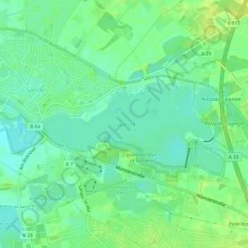
Name: Lippesee topographic map, elevation, terrain.
Average elevation: 328 ft
Minimum elevation: 302 ft
Maximum elevation: 354 ft
Thank you for supporting this site ❤️
Make a donation
Make a donation
Gear up for your next adventure:
As an Amazon Associate, this site earns from qualifying purchases at no extra cost to you.